Trip Facts
Country:
Annapurna Region, Nepal
Duration:
17 Days
Max Altitude:
5,416 m / 17,769 ft (Thorong La)
Activities:
Trekking
Region:
Annapurna Conservation Area, Manang and Mustang
Grade:
Strenuous
Group Size:
1-12 people
Accomodation:
3-star hotel in Kathmandu (2 nights) and Pokhara (1 night), teahouse lodges on trek (13 nights)
Trips Overview
The Annapurna Circuit goes up one river system and down another. You start in the Marsyangdi valley at 760 m among rice terraces and Hindu villages, climb for eight days into Manang, cross Thorong La at 5,416 m, and come down the far side into the Kali Gandaki, which is Tibetan Buddhist, treeless and dry. Two completely different countries, joined by one pass.
That transition is the reason to do this trek rather than an Everest one. The Khumbu is Sherpa from Lukla to Base Camp. Here the language, the food, the architecture and the religion all change under your feet over about a week.
The thing most operator pages will not tell you
There is a road now. Two of them, in fact.
On the eastern side a rough jeep track runs from Besisahar at 760 m all the way through Chame to Manang village at 3,519 m, roughly 100 km of it. On the western side a road runs from Muktinath down through Jomsom, Marpha and Tatopani to Beni and Pokhara, blacktopped in long stretches. Between those two roadheads sits the section that is still genuinely a trek: Manang to Yak Kharka to Thorong Phedi, over the pass, down to Muktinath.
The old 21-day Circuit, walked end to end on foot, does not exist any more in the form the guidebooks described in the 1990s. Anyone selling you that is selling a memory.
What we do instead is drive the sections that are now road and walk the sections that are still trail, and tell you in the itinerary exactly which is which. On Days 4 and 5 we take the high route through Upper Pisang and Ngawal, which climbs away from the valley floor and keeps you off the jeep track for two days. On Day 12 we walk the Lubra valley to Jomsom instead of taking the jeep down the highway. Below Jomsom we drive, because that stretch is a dusty road with trucks on it and calling it trekking would be dishonest.
Thorong La is the whole trek
Everything before Day 11 is preparation for one morning. You leave Thorong Phedi at 4,525 m somewhere between 3am and 4am, climb roughly 900 m in the dark and the cold, and then descend 1,650 m to Muktinath. Eight to ten hours. It is the longest single day we run anywhere.
The pass is not technical. It is a walking route with no rope work and no glacier. What it has is wind, cold, altitude and length, and it closes outright after heavy snow. We have a plan for that, and it is written out in the FAQs rather than buried.
Direction matters
We walk east to west, Besisahar to Muktinath, like almost everyone. The reason is not tradition. Going this way you gain height over eight days and cross the pass with two acclimatisation nights at Manang behind you. Going the other way you would start at Jomsom around 2,720 m, be at Thorong La within three or four days, and climb 2,700 m from the western side in a single push. People have died doing that.
Who should not book this
If you cannot walk for eight hours over rough ground, or if you have never done a multi-day walk of any kind, this is not the trek to start on. If you want a wilderness route with no vehicles anywhere, book Manaslu instead and we will tell you so honestly. And if your dates are late December through February, we will steer you elsewhere, because the pass is often shut.
Trips Highlights
- Cross Thorong La at 5,416 m, the high point of the Circuit and one of the longest trekking days in Nepal
- Walk the high route through Upper Pisang and Ngawal on Days 4 and 5, several hundred metres above the jeep track
- Two acclimatisation days at Manang (3,519 m) instead of one, with an active hike on each
- Watch the country change from Hindu terraced hill villages to Tibetan Buddhist high desert in about a week
- Reach Muktinath (3,760 m), sacred to Hindus and Buddhists alike, with its 108 water spouts and its natural gas flame
- Walk the Lubra valley trail from Muktinath to Jomsom rather than taking the road, past a Bon village few trekkers see
- Travel the Kali Gandaki gorge between Annapurna I and Dhaulagiri, the deepest gorge on earth
- Soak in the hot springs at Tatopani (1,190 m) after the pass
- Sunrise from Poon Hill (3,210 m) over Dhaulagiri, Annapurna South and Machhapuchhare
- Daily oxygen saturation and pulse checks from Day 5, and a second guide on every departure of seven or more
Trips Itinerary
You are met at Tribhuvan International Airport and driven to your hotel in Thamel. Nothing else is scheduled.
Your guide runs the briefing in the evening. We check boots and jacket, confirm your insurance covers 5,500 m, and go through the pass day in detail: the start time, the turnaround time, and what we do if the weather closes it. Tomorrow starts early, so shopping for anything you are missing happens tonight.
Duration:
Transfer 30 to 45 min
Accomodation:
3-star hotel, Kathmandu
A long road day, and there is no honest way around it. Blacktop for 173 km along the Trishuli and then up the Marsyangdi to Besisahar, about 5 to 6 hours. There we change into a 4WD jeep for the rough 60 km up to Dharapani, another 4 hours on a track cut into the valley side.
The old Circuit started walking at Besisahar and took four days to reach Dharapani. That trail is now the jeep road for most of its length. Trekkers who walk it spend those days stepping aside for vehicles and breathing dust, which is why almost nobody does.
The jeep section is bumpy, exposed in places, and slower than the distance suggests. Motion sickness tablets are a good idea. You arrive in the dark in October.
Duration:
9 to 11 hrs drive, 235 km
Accomodation:
Teahouse lodge, Dharapani
First walking day. The trail climbs steadily through Bagarchhap and Danaque into pine and fir forest, with Annapurna II showing above the valley to the south.
Road honesty: the jeep track continues to Chame and beyond, and roughly two hours of today is spent on or beside it. Where a footpath exists we take it, particularly the section through Timang, which climbs away from the road and has the better view. The rest you share with the occasional jeep.
Chame at 2,670 m is the district headquarters of Manang. Grid electricity, mobile signal, a bank, small shops, and hot springs by the river. This is the last town with real infrastructure until Muktinath.
Duration:
5 to 6 hrs trek, 16 km
Accomodation:
Teahouse lodge, Chame
A deliberately short day, and this is where our itinerary parts company with most of them.
Almost every operator walks Chame to Upper Pisang in one go: 630 m of sleeping gain, all of it above 3,000 m. That is over the 500 m per day guideline that every altitude medicine body publishes, on the day you first cross into the altitude that matters. We stop at Dhukur Pokhari instead and gain 570 m, then take a gentler day tomorrow.
The walk goes through the narrow gorge at Bhratang, past the vast curved rock slab of Paungda Danda rising 1,500 m out of the valley, and into a wide upper basin. The vegetation thins visibly. You are leaving the middle hills today.
Duration:
4 to 5 hrs trek, 12 km
Accomodation:
Teahouse lodge, Dhukur Pokhari
The best walking day of the first week, and the one that keeps you off the road.
From Upper Pisang the trail climbs the north side of the valley to Ghyaru at 3,730 m, a steep 400 m pull that most people find is the hardest hour of the trek so far. It pays off immediately. From the terrace above Ghyaru, Annapurna II, III and IV and Gangapurna line up across the valley, and the jeep track is a thin line a long way below you.
Ghyaru and Ngawal are old Tibetan-style villages: flat roofs, stacked firewood, mani walls, prayer flags. The change from the Hindu villages of two days ago is abrupt and it is the point of this trek.
Your guide takes the first oxygen saturation and pulse readings tonight and repeats them every evening from here on.
Duration:
5 to 6 hrs trek, 12 km
Accomodation:
Teahouse lodge, Ngawal
A short day that loses a little height, which is exactly what you want after sleeping at 3,660 m.
The trail drops off the high shelf to the valley floor and follows it west through Braga, where the 500-year-old gompa is built into a cliff above the village and holds a wall of 108 clay statues. Worth the climb up to it. The caretaker will open it if you ask.
Manang is a proper trekking town in a dry, wind-scoured bowl under Gangapurna and its glacier. Bakeries, a couple of shops, gear rental, and the Himalayan Rescue Association post that gives a free altitude talk at 3pm daily in season. We go to it. Every trekker should.
Duration:
3 to 4 hrs trek, 9 km
Accomodation:
Teahouse lodge, Manang
Active rest. We climb the steep path behind the village to Praken Gompa at 3,950 m, where a hermit lama gives blessings to trekkers heading for the pass, then come back down to sleep at 3,519 m. Climb high, sleep low, about 430 m of it.
The afternoon is free. Most people walk out to the Gangapurna glacial lake below the village, or sit in a bakery and do nothing, which is also a legitimate acclimatisation strategy.
Manang is the last place to buy anything: batteries, sunscreen, gloves, chocolate. Prices above here climb steeply and stock runs out.
Duration:
3 to 4 hrs hike, 5 km
Accomodation:
Teahouse lodge, Manang
The day most itineraries do not have, and the reason people finish this trek with us rather than turning back at Yak Kharka.
We climb the switchbacks above Braga towards Kicho Tal, the Ice Lake. The full lake sits at 4,600 m and is a hard 1,100 m climb. We go to around 4,300 m as standard, which is high enough to do real work on your blood chemistry, and continue to the lake only if the whole group is moving well and the weather is good.
Then all the way back down to 3,519 m to sleep. Spending a few hours at 4,300 m and sleeping 800 m below it is worth more than an extra night at Yak Kharka.
This is also our decision point. If your saturation readings are poor, or you have had two bad nights, we would rather find out here, where a jeep can reach you, than at Thorong Phedi where nothing can.
Duration:
5 to 6 hrs hike, 10 km
Accomodation:
Teahouse lodge, Manang
You leave the road behind for good today. From here to Muktinath there is no vehicle access of any kind.
The trail climbs steadily out of Manang past Tengi and Gunsang, turning north up the Jarsang valley. Trees stop. What is left is juniper scrub, blue sheep on the slopes above, and the occasional lammergeier. Yak Kharka means yak pasture, and that is precisely what it is: a few stone lodges and grazing.
531 m of sleeping gain, which is at the top end of what we are comfortable with, and the reason the last two days were spent at Manang.
Drink more than you want to. Eat more than you want to. Both get harder from here.
Duration:
4 to 5 hrs trek, 10 km
Accomodation:
Teahouse lodge, Yak Kharka
A short morning on purpose. You want to arrive by lunchtime with the afternoon free.
The trail crosses the river at Ledar and then traverses a landslide-prone slope where the path is narrow and the drop is real. This section needs care in wind and is genuinely dangerous with loose scree underfoot. Your guide will space the group out.
Thorong Phedi is two lodges at the foot of the climb, nothing else. Rooms are basic, often dormitory in October, and the dining room is the only warm place. Do not expect a hot shower to be worth the money.
In the afternoon we walk 45 minutes up towards High Camp and come back. It is unpleasant and it works, and it also lets you see the first section of tomorrow’s climb in daylight.
On High Camp. Some operators sleep at High Camp at 4,880 m to shorten the pass day. We do not, as a rule. It is 355 m higher on the night you most need sleep, the lodges are worse, and the accident record on the pass does not favour it. If the group is strong, well acclimatised and space is available, your guide may offer it. That is a judgement made on the day, not a promise made in an office.
Duration:
3 to 4 hrs trek, 7 km
Accomodation:
Teahouse lodge, Thorong Phedi
The day the whole trek is built around. We wake at 3am and start walking between 3.30am and 4am, in the dark, by head torch.
The first hour is the steepest of the trek: a set of switchbacks up to High Camp at 4,880 m that gains 355 m and takes most people 60 to 90 minutes. After that the angle eases into a long series of false summits across a high, open, stony bowl. The pass keeps looking close and keeps not being close. That is the part people find psychologically hard.
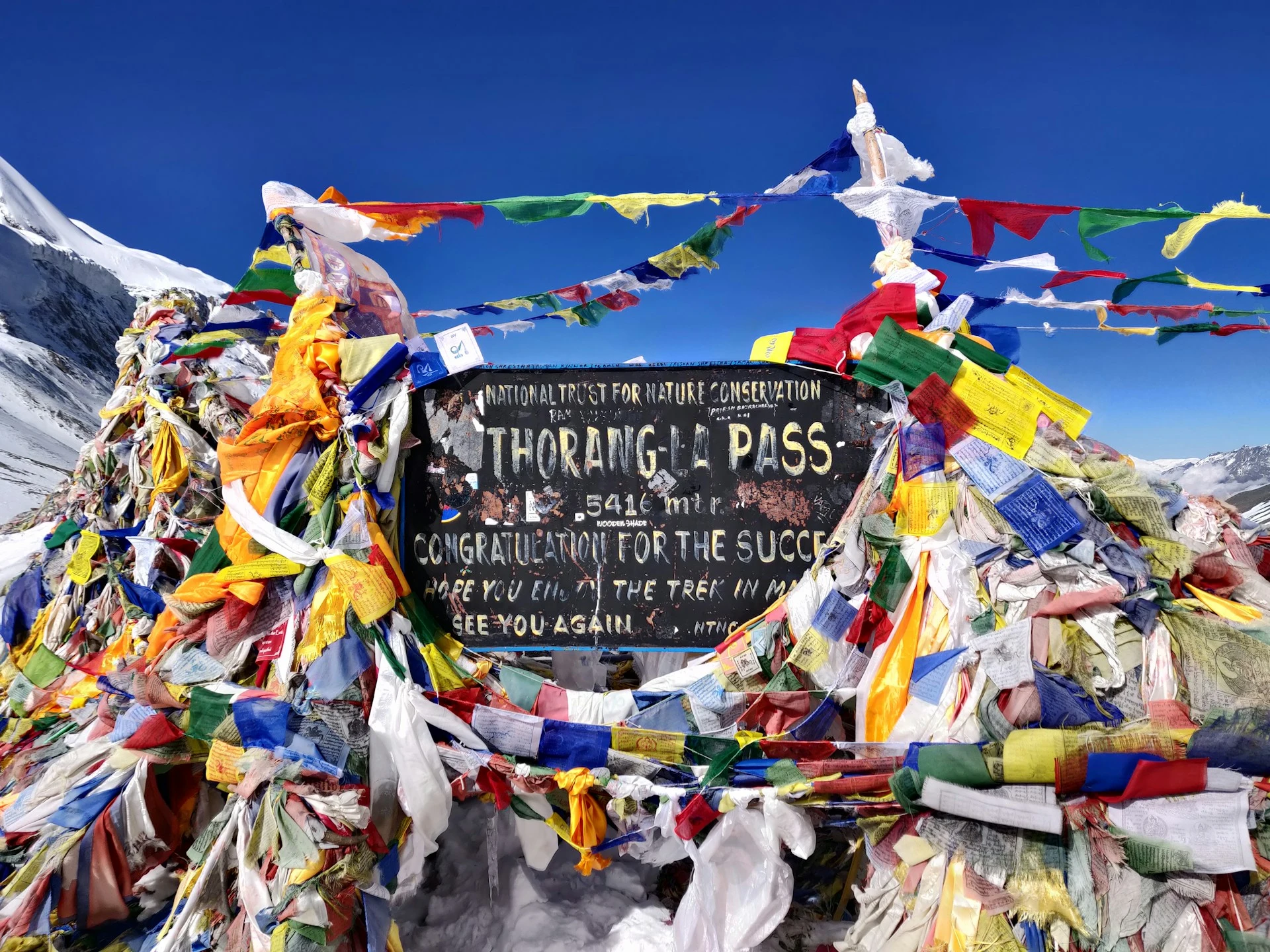
The cairn and prayer flags at 5,416 m usually come between 8am and 10am. Dhaulagiri stands across the Kali Gandaki to the west, the Annapurnas are behind you, and there is a tea shack that sells the most expensive and most welcome cup of tea in Nepal. Do not linger more than 20 minutes. It is cold and there is a lot of day left.
Why the early start. Wind, not sunrise. Thorong La funnels air between two 8,000 m massifs and it reliably picks up from late morning. Crossing at 11am in a 60 km/h headwind is a different and worse experience.
Then the descent, which is the part nobody trains for: 1,650 m down loose scree and dust to Muktinath, three to four hours of it, hard on the knees and the toes. Poles out. This is where blisters and black toenails happen.
Muktinath is a shock after the pass. Green irrigated fields, a road, jeeps, shops, and a temple complex sacred to both Hindus and Buddhists, with 108 stone water spouts and a flame that burns from natural gas above a spring. You will be too tired to appreciate it properly today. Go in the morning.
Duration:
8 to 10 hrs trek, 16 km
Accomodation:
Teahouse lodge, Muktinath
Visit the temple early, then walk. Most groups take a jeep down the highway to Jomsom in 90 minutes. We do not, and this is one of the better decisions on the itinerary.
The Lubra route leaves the road at Khingar, climbs a bare ridge to about 3,700 m, then drops into a hidden side valley to Lubra, a village of maybe fifteen houses that follows Bon, the pre-Buddhist religion of Tibet. The gompa there is one of the few working Bon monasteries on any trekking route in Nepal.
From Lubra the trail follows the river bed down to the Kali Gandaki and into Jomsom. The last hour is exposed to the valley wind, which by early afternoon is fierce and full of grit. Buff on.
Jomsom at 2,720 m has an airstrip, an army post, a bank and hotels with heating. It is the administrative centre of Mustang.
If your knees took a beating on the pass yesterday, the jeep is available instead and there is no charge either way. Say so at breakfast.
Duration:
6 to 7 hrs trek, 18 km
Accomodation:
Teahouse lodge, Jomsom
A driving day, stated plainly. The old trail down the Kali Gandaki is now a road carrying jeeps, buses and supply trucks, and walking it means seven hours of dust and traffic. We drive it and we do not call it trekking.
The drive itself is good. You go through Marpha, a whitewashed Thakali village famous for apple brandy, where we stop. Then Tukuche and Kalopani, with Dhaulagiri at 8,167 m on one side and Annapurna I at 8,091 m on the other, and only 6 km of horizontal distance between them. That is what makes this the deepest gorge on earth.
You lose 1,530 m of altitude in an afternoon. Trees come back, then bananas and citrus. Tatopani means hot water, and the springs by the river are the reason to stop here. Go in before dinner.
Duration:
5 to 6 hrs drive, 75 km
Accomodation:
Teahouse lodge, Tatopani
The hardest day after the pass, and people do not see it coming.
1,684 m of ascent, most of it on stone staircases, through Ghara, Sikha and Chitre. It is hot at the bottom, and humid in a way the dry Mustang side was not. Six to eight hours of climbing when you thought the trek was over.
The compensation is the country. You are back in the middle hills: terraced fields, water buffalo, Magar villages, and above Chitre a rhododendron forest that in late March and April is scarlet from the trail to the ridge.
Ghorepani sits on a saddle at 2,874 m with Dhaulagiri filling the western sky. Cold at night, blankets on the beds, and a lot of trekkers, because this is where the Poon Hill crowd from Pokhara arrives too.
Duration:
6 to 8 hrs trek, 15 km
Accomodation:
Teahouse lodge, Ghorepani
Up at 4.30am for the 45-minute climb to Poon Hill. You will not have it to yourself. On an October morning there can be 200 people on that summit, and that is simply the deal.
What you get is Dhaulagiri, Tukuche Peak, Nilgiri, Annapurna South and Machhapuchhare turning gold in sequence. Having walked past most of them over the last two weeks, you can name them all, which the day-trippers cannot.
Back for breakfast, then a long descent through Ulleri, including the notorious 3,300 stone steps down to Tikhedhunga. Poles again. The knees do not enjoy today.
From Birethanti a private vehicle takes you to Pokhara in about 90 minutes. Hot shower, clean clothes, a bed with a mattress and dinner by the lake. Most groups sleep badly out of sheer overexcitement.
Duration:
6 to 7 hrs trek plus 1.5 hr drive, 17 km
Accomodation:
3-star hotel, Pokhara Lakeside
Tourist bus along the Prithvi Highway, following the Marsyangdi and then the Trishuli. Seven to eight hours, with stops. The road is busy and the driving is Nepali, so bring a book and low expectations.
The 25-minute flight is an alternative at your own cost and we will book it if you ask at least a week ahead. In October the seats go early.
Evening in Kathmandu: farewell dinner at a Nepali restaurant and trip completion certificates.
Duration:
7 to 8 hrs drive, 200 km
Accomodation:
3-star hotel, Kathmandu
Transfer to the airport about three hours before your flight.
If you have a spare day, Bhaktapur is the best use of it, or Boudhanath, which will feel familiar after Manang and Mustang. We can also arrange onward travel to Chitwan or Lumbini.
Duration:
Transfer 30 to 45 min
Accomodation:
Departure day
Trips Include
Everything below is inside the trek price. Quantities are stated because vague inclusions are where trekking budgets quietly break.
- Airport transfers on arrival and departure in Kathmandu, in a private vehicle
- 2 nights in a 3-star Kathmandu hotel and 1 night in a 3-star hotel in Pokhara Lakeside, twin-share with breakfast
- 13 nights in teahouse lodges on trek, twin-share where rooms allow. Thorong Phedi is often dormitory only and we say so in advance
- All meals on trek: 13 breakfasts, 13 lunches and 13 dinners, with tea or coffee at every meal
- Fresh seasonal fruit after dinner each evening on the trail
- Farewell dinner in Kathmandu at a Nepali restaurant on your return
- Purified drinking water throughout the trek, so you never need to buy a plastic bottle
- Private vehicle Kathmandu to Besisahar, and a shared 4WD jeep Besisahar to Dharapani on the rough section, which is the only vehicle that can do it
- Jeep Jomsom to Tatopani on Day 13, private for groups of 4 or more and shared for smaller groups
- Private vehicle Birethanti to Pokhara, and tourist bus Pokhara to Kathmandu
- Licensed, English-speaking trekking guide trained in wilderness first aid who has crossed Thorong La in season
- A second guide on every departure of 7 or more, so the group can split if someone has to turn back at the pass
- One porter per two trekkers, carrying up to 12 kg each
- All guide and porter wages, meals, accommodation, equipment, insurance and medical cover
- Annapurna Conservation Area Permit (ACAP), NPR 3,000
- TIMS card, NPR 2,000 individual or NPR 1,000 group rate. Enforcement is currently disputed on the Annapurna trail, so we obtain it anyway rather than risk you being turned back
- Comprehensive first aid kit carried by your guide, including a pulse oximeter used at daily altitude checks from Day 5
- Everest Women Treks duffel bag, trekking map, sun hat and buff, yours to keep
- Trip completion certificate
- All government taxes, VAT and company administrative costs
Guide and porter wages, insurance, equipment, food and lodging are ours to pay and already sit inside the price. You are never asked to top up staff costs on the trail. All road transport listed above is included, in a private vehicle except for the one shared jeep stretch we flag on Day 13.
Trips Exclude
These sit outside the package. Budget roughly USD 300 to 500 beyond the trek price for 17 days. Lodge charges on the Circuit are lower than in the Khumbu because supply comes in by road for most of the route, which is one of the few clear benefits of the jeep track.
- International flights to and from Kathmandu
- Nepal entry visa: USD 50 for 30 days, which is the one a 17-day trip needs, available on arrival
- Lunch and dinner in Kathmandu and Pokhara, other than the included farewell dinner
- Travel insurance, which must cover helicopter evacuation and medical treatment to 5,500 m
- Pokhara to Kathmandu flight if you prefer 25 minutes in the air to 7 hours on the Prithvi Highway. We will book it for you
- Jomsom to Pokhara flight if you want to end the trek at Jomsom and skip Tatopani and Poon Hill
- Bottled and boiled water, soft drinks, alcohol and hot chocolate on the trail
- Hot showers, roughly USD 2 to 5, and gas heating in the dining room where a lodge charges for it
- Device charging on the trail, roughly USD 1 to 5 per device, free in most lodges below Chame where there is grid power
- Wifi on the trail, roughly USD 2 to 5 per day above Manang
- Personal trekking clothing and equipment
- Sleeping bag and down jacket if you rent rather than bring your own, about USD 35 each for the trek
- Tips for your guide, porters and drivers, customarily 10 to 15% of the trip cost, given as a group at the end
- Extra nights and meals if snow closes Thorong La and we wait it out
- Emergency evacuation costs, which your insurer reimburses
- Anything not listed under what is included
Travel insurance covering helicopter evacuation and medical treatment to 5,500 m is required, not recommended. Thorong Phedi and the pass itself have no road access, and the nearest hospital of any size is in Pokhara. Check the altitude ceiling in the policy wording rather than assuming, and send us the certificate before you fly.
Packaging Lists
The four things that actually matter here
A windproof shell that genuinely works. Thorong La is a wind tunnel. The pass funnels air between Annapurna and Dhaulagiri, and on a normal morning you are walking into 30 to 50 km/h of it at minus 10C. A soft fleece and a cheap rain jacket will not do.
Broken-in boots. The descent from the pass to Muktinath drops 1,650 m on loose scree and takes four hours. That descent, not the climb, is what ruins toenails and knees. Walk at least 80 km in your boots before you fly.
Both trekking poles. Not one. See the descent above.
A buff or dust mask. The Kali Gandaki side is dry and windy, jeeps pass on the lower road, and Marpha to Tatopani is dusty in any season. Everyone regrets not having one.
Sleeping
A bag rated to minus 15C comfort is enough on this trek. You sleep only three nights above 4,000 m and lodges below Manang are warmer than their Khumbu equivalents. Comfort rating, not extreme rating.
Upper body
3 base layers in merino or synthetic, 1 fleece, 1 down or synthetic insulated jacket, 1 waterproof windproof shell. No cotton.
Lower body
2 pairs trekking trousers, 1 pair thermal leggings, waterproof over-trousers, 5 pairs underwear, 5 pairs trekking socks plus a thick pair kept only for sleeping.
Head, hands and feet
Sun hat, warm hat that covers the ears, buff, category 3 or 4 sunglasses, liner gloves, insulated outer gloves, boots, camp shoes or sandals.
For women
Bring enough menstrual supplies for the whole trek plus a week. Jomsom and Manang have small shops but stock is unreliable and nothing at all is sold between Manang and Muktinath. Sealable opaque bags for used products, which are carried out. A pee funnel if you use one, practised at home rather than on the pass at 4am.
Health and documents
Personal first aid kit, blister plasters, rehydration salts, prescription medication in original packaging with a copy of the prescription, sunscreen SPF 50, SPF lip balm, headlamp with spare batteries, passport, four passport photographs, insurance certificate, and rupees in small notes.
Bags
One duffel of up to 12 kg carried by your porter, and we provide the duffel. Plus a 25 to 35 litre daypack. On the pass day your daypack carries three litres of water, all your warm layers and your lunch, so make sure it actually holds that.
Trips Altitude
Trips FAQs
These are the questions we are actually asked, and the first three are the ones that decide whether this trek is right for you.
This is the question that matters most and the one most operator pages avoid.
A jeep road runs from Besisahar at 760 m all the way to Manang village at 3,519 m, roughly 100 km. A second road runs from Muktinath at 3,760 m down through Jomsom and Tatopani to Beni and Pokhara. Both are used daily by jeeps, buses and supply trucks.
On this 17-day itinerary you walk on 10 days and ride on 4. The walking days are Days 3, 4, 5, 6, 7, 8, 9, 10, 11, 12, 14 and 15, with Days 7 and 8 being acclimatisation hikes from Manang. The driving days are Day 2 (Kathmandu to Dharapani), Day 13 (Jomsom to Tatopani), Day 16 (Pokhara to Kathmandu) and the short transfer at the end of Day 15.
Of the walking, roughly two hours on Day 3 is on or beside the jeep track. Everything from Day 4 onwards is on footpath, because we take the high route through Ghyaru and Ngawal and then the Lubra valley on the far side. Days 9 to 11, Manang to Thorong La to Muktinath, have no road anywhere near them.
If someone sells you a 21-day Circuit walked entirely on trail, ask them which days are on the road. The answer will be evasive.
It has changed it. Whether that ruins it depends on what you came for.
What is lost: the long approach on foot from Besisahar through Bhulbhule and Jagat, four days of subtropical valley walking that used to ease you into the trek. And the walk down the Kali Gandaki through Marpha and Kalopani, which was lovely and is now a dusty road.
What survives intact: the entire high section. Manang, Yak Kharka, Thorong Phedi, the pass and the descent to Muktinath cannot be driven and never will be. The high trails through Ghyaru and Ngawal are better than the valley floor route they replaced. And the cultural change from Hindu hills to Tibetan high desert is exactly as it always was.
The road also brought real benefits people rarely mention: cheaper food, better lodges, faster evacuation if you get sick, and no need to spend four days walking a valley just to get to the good part.
If you want a route with no vehicle anywhere, do Manaslu instead. We run it and we will happily tell you it is the better choice for that.
Thorong La is 5,416 m (17,769 ft). Be careful with sources on this: some operator pages quote 5,316 m or 5,400 m, and at least one page states both 5,416 m and 5,316 m on the same page. The surveyed figure is 5,416 m.
The day is the longest we run anywhere: 8 to 10 hours, 891 m of ascent from Thorong Phedi, then 1,656 m of descent to Muktinath, 16 km in total, starting at 3.30am to 4am in the dark.
It is not technical. No rope, no glacier, no scrambling. What makes it hard is the combination of altitude, cold, wind and length, and the fact that once you are past High Camp there is no shelter and no way down except forward.
Most people find the descent harder than the climb. 1,656 m on loose scree with tired legs is where the injuries happen.
We wait, then we turn around. Here is the sequence, so you know it before you book.
First we wait at Manang or Yak Kharka. Most closures clear in one to three days once the local operators break trail again. We have spare capacity in the schedule for a short delay, and your guide talks to the lodge owners and the police post at Thorong Phedi every evening about conditions.
If it stays shut, we walk back down to Manang and take a jeep out to Besisahar and Pokhara, then use the remaining days for the Ghorepani and Poon Hill section of this itinerary, which is unaffected. You get a trek, just not the pass.
What we will not do is push a group over in deep fresh snow. In October 2014 a storm killed more than 40 people on and around this pass, most of them on the Thorong La crossing itself, in conditions that had been forecast. That event is the reason Nepal’s forecasting and check-post system exists in its current form, and it is the reason we will lose a pass rather than gamble on one.
Closures are most likely in late December through February, and after unseasonal storms in October and April. In a normal season the pass is open the great majority of days.
You can. You should not, and no responsible operator will run it that way.
Walking east to west from Besisahar you gain height over eight days, sleep two nights at Manang at 3,519 m, and reach the pass having spent five nights above 3,000 m. The final climb to 5,416 m is 891 m from Thorong Phedi.
Reversed, you start at Jomsom around 2,720 m, and the far side of the pass rises much more steeply. You would be climbing roughly 1,650 m from Muktinath to the pass with barely three days of acclimatisation behind you, and the west side has no equivalent of Yak Kharka and Thorong Phedi to break it up. That is a recipe for high altitude cerebral or pulmonary oedema at 5,000 m, a long way from help.
The descent direction matters too. Coming down 1,656 m into Muktinath is unpleasant. Coming down the east side, which is longer and rougher, at the end of a day that started with a 1,650 m climb, is worse.
Because one is not enough for what comes next, and because Manang is the last place where a jeep can reach you.
Standard itineraries give you a single rest day at Manang and then go Manang, Yak Kharka, Thorong Phedi, pass. That is three consecutive nights of gain (531 m, 475 m, then a 891 m climb) with only one adaptation day behind them.
We add a second day, and both are active: Praken Gompa at 3,950 m on Day 7, then a climb towards Ice Lake to about 4,300 m on Day 8, sleeping at 3,519 m both nights. Climbing 800 m above your sleeping altitude and coming back down does more for acclimatisation than resting flat does.
The other reason is diagnostic. By the evening of Day 8 your guide has four nights of oxygen saturation and pulse readings. If the trend is wrong, we act at Manang, where a jeep can take you out in a day. At Thorong Phedi the only options are walking or a helicopter.
It costs a day. It is the difference between finishing and not.
Two, and both are included in your price.
Annapurna Conservation Area Permit (ACAP), NPR 3,000 for foreign nationals and NPR 1,000 for SAARC nationals. This one is compulsory and it is genuinely checked, at Dharapani, Chame, Manang, Jomsom and Ghorepani. No ACAP means no trek.
TIMS card, NPR 2,000 at the individual rate or NPR 1,000 through a registered agency as part of a group, issued by the Nepal Tourism Board and TAAN.
The honest position on TIMS: its status is disputed. It has not been formally abolished for Annapurna the way it was in the Everest region, where the Khumbu Pasang Lhamu Rural Municipality permit replaced it outright. But since 2025 several checkposts on the Annapurna trail have reportedly been inspecting ACAP only, and trekkers report never being asked for TIMS at all. Nothing official has changed the requirement.
So we buy it. The fee is small and being turned back at Dharapani or argued with at a Jomsom police post costs a great deal more than the card does. Anyone telling you flatly that TIMS is dead, or flatly that it is strictly enforced, is more certain than the situation allows.
We arrange both from Kathmandu. Bring your passport and four passport photographs.
You need to walk 6 to 7 hours on consecutive days over rough ground, and once, on Day 11, for 8 to 10 hours starting at 4am.
Ten weeks of preparation, minimum. Three hill or stair sessions a week plus a long weekend walk with a loaded pack.
Train the descents specifically. Almost nobody does, and it is the single biggest gap we see. Days 11, 14 and 15 involve 1,656 m, then a long climb, then 1,700 m down including 3,300 stone steps. Downhill loads your quads and knees in a way that flat treadmill work does not touch. Find a hill and walk down it repeatedly.
You do not need to be an athlete. The people who struggle on this trek are usually not the unfit ones. They are the ones who ignored the altitude advice or who trained only for going up.
No, and this is a reasonable first Himalayan trek, which the Three Passes and Manaslu are not.
The first week is genuinely gentle: 4 to 6 hour days at moderate altitude with good lodges. It gives you time to work out how your body handles thin air before anything serious is asked of you.
What you do need is multi-day walking experience of some kind, even at sea level, and honesty about your fitness. Tell us at booking if you have never walked more than four hours in a day, and we will talk about whether Ghorepani and Poon Hill or Annapurna Base Camp is a better fit this year.
Minimum age on this trek is 14 with a parent. There is no upper limit. We have taken people in their seventies over Thorong La. Fitness and attitude decide it, not the birth date.
Acute Mountain Sickness is your body reacting to less oxygen. Headache, nausea, poor sleep and breathlessness are common and mild. The dangerous forms, fluid on the lungs or the brain, are rare and treated the same way: descend, immediately.
The Circuit has a specific risk profile. The first week is slow and safe. Then it gets high quickly, and Thorong La at 5,416 m is higher than Everest Base Camp.
What we build in: two active acclimatisation days at Manang, a split Chame to Dhukur Pokhari day so that no sleeping gain above 3,000 m exceeds about 570 m, a short day into Thorong Phedi, and daily oxygen saturation and pulse checks from Day 5. Your guide carries a pulse oximeter and a first aid kit, and knows what the numbers mean rather than just writing them down.
The Himalayan Rescue Association post at Manang gives a free altitude talk daily in season. We attend it as a group.
On Diamox: it works, it is not a substitute for a sensible profile, and it is your doctor’s decision, not ours. If you plan to take it, trial it at home first. Some people react badly to it.
Where you are decides the options, and the road actually helps here.
Anywhere up to Manang: a jeep can reach you. Manang to Besisahar takes a day, and Besisahar to Kathmandu or Pokhara another. Straightforward and cheap.
Yak Kharka or Thorong Phedi: you walk back down to Manang, which is a long but easy day, and then take the jeep. There is no road above Manang.
Muktinath onwards: a road and a jeep, plus an airstrip at Jomsom with flights to Pokhara.
A genuine medical emergency means a helicopter, which your insurer covers. Landing sites exist at Manang, Thorong Phedi and Muktinath. Cloud can ground them, which is why we descend on foot rather than waiting for a helicopter whenever descent is possible.
On departures of seven or more there is a second guide, so someone can go down with you while the group continues. There is no charge for a guide accompanying you.
Mid October to late November is the best window. Clear air after the monsoon, stable weather on the pass, and the sharpest mountain views of the year. It is also the busiest, and Thorong Phedi fills early in mid October.
March to mid May is the other good one. Warmer, hazier views, more chance of afternoon cloud, and rhododendron in flower between Tatopani and Ghorepani from late March. Slightly more snow on the pass in early March.
Late December to February: we do not run it. Thorong La holds deep snow and closes for days at a time, several lodges at Yak Kharka and Thorong Phedi shut, and the ones that stay open are very cold.
June to mid September is monsoon. Leeches and landslides on the Besisahar road, cloud instead of views. The one exception is that Manang and Mustang sit in the rain shadow and stay comparatively dry, so a Jomsom to Muktinath trip works in summer. The full Circuit does not.
Better than the Khumbu below Manang, and worse above it.
Because supplies come in by road as far as Manang, lodges in Chame, Pisang, Ngawal and Manang are comfortable and cheap: solid buildings, decent menus, attached bathrooms in places, bakeries in Manang. Grid electricity as far as Chame.
Above Manang it changes fast. Yak Kharka is a few stone lodges. Thorong Phedi is two lodges and nothing else, often dormitory-only in peak season, unheated rooms, shared squat toilets, and everything carried up by mule. Expect to be cold. It is one night.
Muktinath onwards is comfortable again, and Jomsom hotels have heating.
Rooms are twin-share throughout. Single rooms are not available at Thorong Phedi in October at any price, and we would rather tell you that now than on the day.
USD 300 to 500 for 17 days, which is less than a Khumbu trek needs. Road access keeps prices down.
Typical costs: hot shower USD 2 to 5, device charging USD 1 to 5, wifi USD 2 to 5 a day above Manang, a large bottle of soft drink USD 2 to 4. Charging is free in most lodges below Chame.
Bring Nepali rupees in small notes. There are ATMs at Besisahar, Chame, Manang and Jomsom, but they run out of cash in peak season and Manang’s is offline more often than not. Draw what you need in Kathmandu and treat the mountain ATMs as a bonus.
Tipping is customary at 10 to 15% of the trip cost, pooled by the group and handed over on the last evening. Drivers are tipped separately and modestly.
A policy that explicitly covers trekking to 5,500 m and includes helicopter evacuation and medical repatriation. Standard travel insurance usually caps altitude cover at 3,000 or 4,000 m, which is below Manang, let alone the pass.
Read the wording rather than the marketing page. The phrase to look for is a stated altitude limit for trekking without ropes or technical equipment. If it is not written down, assume you are not covered.
Send us the certificate before you travel. We check it, and we will not take you above Manang without it.
Nepal requires helicopter rescues to be authorised and paid for up front, then reimbursed. Make sure you have a credit card with headroom or an insurer with a 24-hour assistance line that will guarantee payment.
Yes. Solo travellers make up a large share of most departures, and you are with a licensed guide from Kathmandu to Kathmandu.
Twin-share rooms are allocated with someone of the same sex unless you book a single, though at Thorong Phedi in peak season the rooms are often dormitories and nobody gets a choice.
The Annapurna trail is one of the busiest in Nepal and the villages are used to trekkers. Practical points: dress modestly in the Hindu villages of the lower Marsyangdi and around the Muktinath temple, carry a headlamp for the toilet at night, and tell your guide rather than tolerating anything that makes you uncomfortable.
There is no solo supplement on the trek itself. It applies only to hotel nights in Kathmandu and Pokhara if you want your own room.
Good to Know
These are the questions we are actually asked, and the first three are the ones that decide whether this trek is right for you.
Two decades of road building have changed this trek more than any other in Nepal. Here is the current position, stated the way we would state it to your face.
Eastern side. Blacktop runs 173 km from Kathmandu to Besisahar at 760 m. From there a rough 4WD track climbs about 60 km to Dharapani at 1,860 m, then continues through Chame at 2,670 m and on to Manang village at 3,519 m. That is roughly 100 km of the old walking Circuit now driveable.
Western side. A road runs from Muktinath at 3,760 m down through Kagbeni and Jomsom, then the length of the Kali Gandaki through Marpha, Tukuche, Kalopani and Tatopani to Beni and Pokhara. Long stretches are blacktopped and it carries buses and supply trucks daily.
What is still trail, and always will be. Manang to Yak Kharka to Thorong Phedi, over Thorong La at 5,416 m, down to Muktinath. No road, no vehicle, no possibility of one.
How we handle it. Day 2 and Day 13 are driving days and we call them driving days. On Day 3 about two hours are on or beside the track, and we use the Timang footpath where it exists. From Day 4 we take the high trails through Upper Pisang, Ghyaru and Ngawal, several hundred metres above the valley floor and out of sight of the road for two days. On Day 12 we walk the Lubra valley to Jomsom rather than taking the highway jeep.
Marked alternative footpaths, signed in red and white, exist along parts of the Marsyangdi and the Kali Gandaki. Some are good. Others have been swallowed by the road or by landslides, and which is which changes season by season. Your guide knows the current state of them, which a printed itinerary cannot.
The road is not all loss. Food is cheaper, lodges are better built, mail and medicine get in, and a sick trekker below Manang can be in a Pokhara hospital the same day. Ask an old Circuit hand and they will complain about the dust. Ask a Manang shopkeeper and you get a different answer.
The numbers. Thorong La is 5,416 m. From Thorong Phedi at 4,525 m you climb 891 m and then descend 1,656 m to Muktinath at 3,760 m. About 16 km. Eight to ten hours.
The timings. Wake 3am, eat, walk by 3.30am to 4am. High Camp at 4,880 m in 60 to 90 minutes, the steepest section of the whole trek. The pass between 8am and 10am. Muktinath by early to mid afternoon.
Why so early. Wind, not the view. The pass sits between the Annapurna and Dhaulagiri massifs and reliably funnels wind from late morning. A 10am crossing in a headwind is a different day, and a worse one.
The turnaround rule. If the group is not at High Camp within two hours, or the weather is deteriorating, we turn around and go back to Thorong Phedi. Nobody is talked into continuing. There is no shelter between High Camp and the descent to Muktinath, which is what makes this pass unforgiving of a late start.
If the pass is closed by snow. First we wait, at Manang or Yak Kharka, and most closures clear within one to three days. If it stays shut, we walk back to Manang, take a jeep out to Pokhara, and use the remaining days on the Ghorepani and Poon Hill section, which is unaffected by snow at the pass. You lose the pass. You do not lose the trip.
We will not push a group over in deep fresh snow. The October 2014 storm killed more than 40 people on and around this crossing, in conditions that had been forecast. That is the whole argument.
This trek is not consistently high. It is low for a week and then it is very high for three days, and that shape is what catches people out.
You sleep only three nights above 4,000 m: Yak Kharka, Thorong Phedi and, if you count it, nothing else. But Thorong La at 5,416 m is higher than Everest Base Camp, and you reach it on Day 11 rather than Day 12 or 13.
Our sleeping profile above 3,000 m: Chame 2,670, Dhukur Pokhari 3,240 (+570), Ngawal 3,660 (+420), Manang 3,519 (down 141), Manang again, Yak Kharka 4,050 (+531), Thorong Phedi 4,525 (+475). No night gains more than about 570 m, and the two Manang nights sit in the middle of it.
Compare that with the common 16-day itinerary, which goes Chame to Upper Pisang in one push: 630 m of gain on the first night that really matters.
What we do daily. Oxygen saturation and resting pulse from Day 5, recorded each evening. The trend across four evenings tells your guide far more than any single reading. We attend the free Himalayan Rescue Association altitude talk at Manang as a group.
What we ask of you. Three to four litres of water a day. Eat when your appetite has gone, which it will. No alcohol above Chame. And tell your guide about a headache on the evening it starts, not on the morning of the pass.
Better than most Himalayan treks for the first week, then basic for three days.
Hot showers work reliably and cheaply at Dharapani, Chame, Pisang, Ngawal and Manang, usually USD 2 to 5, because there is grid or micro-hydro power. Above Manang they are unreliable, and at Thorong Phedi a shower is not worth the chill that follows. Most people wash properly at Manang, then use unscented wet wipes and a quick-dry towel until Muktinath.
Bring your own toilet paper and hand sanitiser. Lodge toilets at Yak Kharka and Thorong Phedi are shared squat toilets, often outside, and freeze at night. A headlamp matters for that walk at 2am.
Rooms are twin-share, walls are thin plywood, and most doors have no lock. Bring a sarong or light towel to change under. Thorong Phedi in October is frequently dormitory only.
Drink fully even though it means getting up in the cold. Urinary tract infections are common on trek precisely because people cut back on water to avoid the night walk, and dehydration also makes altitude symptoms worse.
Women should carry enough menstrual supplies for the whole trek plus a week. Manang and Jomsom have small shops with unreliable stock and there is nothing at all between Manang and Muktinath. Altitude and sustained exertion often shift cycle timing. Used products are carried out in sealable opaque bags, since there is no disposal on the trail. Worth mentioning to your guide, because cramps and fatigue look a lot like early altitude sickness.
Every departure runs with a licensed, English-speaking guide trained in wilderness first aid who has crossed Thorong La in season. On this route, judgement about the pass is the whole job, and that only comes from having stood at Thorong Phedi at 3am in bad weather and made the call.
Departures of seven or more carry a second guide, so if someone has to turn back at High Camp the group does not have to turn back with them.
Groups are capped at twelve. We take single bookings, and there is no solo supplement on the trek itself.
Porters carry up to 24 kg shared between two trekkers, so 12 kg each from you in the duffel we provide. Above Manang, mules and porters bring everything in, which is why a bottle of water at Thorong Phedi costs what it does.
All staff are insured, equipped with boots, jackets and eyewear suitable for a 5,416 m pass, paid above the government minimum, fed and accommodated at our cost. Our porters cross the same pass you do on the same morning, and they are equipped for it. That is not universal on this route and it is worth asking any operator about.
Budget USD 300 to 500 beyond the trek price for 17 days. Lower than a Khumbu trek, because road access keeps lodge prices down.
ATMs exist at Besisahar, Chame, Manang and Jomsom. Treat them as a bonus rather than a plan. They run out of notes in October and the Manang machine is offline as often as not. Draw rupees in Kathmandu, in small denominations, because a lodge at Yak Kharka cannot change a 1,000 rupee note at breakfast.
Charging is free in most lodges as far as Chame, where there is grid power. Above that expect USD 1 to 5 per device. A 20,000 mAh power bank removes the problem entirely. Cold flattens batteries fast, so sleep with your phone and power bank inside your sleeping bag.
Mobile coverage is good as far as Manang on NTC and Ncell, patchy at Yak Kharka, absent at Thorong Phedi and on the pass, and good again from Muktinath. Wifi runs USD 2 to 5 a day above Manang and is slow. Tell people at home they will not hear from you for two days around the pass.
We include purified water throughout so nobody buys a plastic bottle. ACAP has safe drinking water stations along much of the route and they work. Bottled water on this trail is both expensive and a genuine waste problem, because what does not get carried out gets burned.
Carry out everything you carry in, including wrappers, batteries and sanitary waste. The road makes rubbish collection easier below Manang and does nothing for the high section.
Walk clockwise around mani walls, chortens and prayer wheels, keeping them on your right. Ask before photographing people, particularly monks at Braga and pilgrims at Muktinath. Muktinath is an active pilgrimage site for both Hindus and Buddhists, not a viewpoint. Dress accordingly and take your boots off where you are asked to.
Mule trains have right of way and they do not stop. Step to the inside of the trail, against the hillside, never the drop side. This matters on the traverse above Ledar on Day 10, where the drop is real.
Where there is a choice we use locally owned lodges and buy local. In Manang and Mustang, tourism is most of the cash economy, and which lodge you sleep in is a decision with consequences.
We run this trek from one person upwards and cap groups at twelve.
A 20% deposit confirms your place. The balance is due in Kathmandu before you leave for Besisahar.
Book three to four months ahead for October and April. The pinch point is Thorong Phedi, where there are two lodges for the entire route and they fill by early afternoon in mid October.
Cancel more than 30 days out and the deposit is refundable less bank charges. Inside 30 days it is retained but transferable to another departure within 12 months.
A closed pass is not a cancellation. If Thorong La is shut we take the alternative described above and the trek continues at the same standard, with no refund due and none charged for the change.
Tell us your trekking history when you enquire. If we think Annapurna Base Camp or Ghorepani suits you better this year, we will say so. That conversation costs us bookings occasionally and it costs us far less than the alternative at 5,416 m.
We run this trek from one person upwards and cap groups at twelve. There is no solo supplement on the trek itself, only on the hotel nights in Kathmandu and Pokhara if you want a single room.
Book three to four months ahead for October and April. Lodge space at Thorong Phedi is the pinch point: there are only two lodges, and in mid October they fill by early afternoon.
A 20% deposit holds your place, with the balance due in Kathmandu before you leave for Besisahar.
Tell us your trekking history when you enquire. Not as a formality. This trek has one very hard day and eight easy ones, and people underestimate it precisely because the first week is gentle.
Keep two spare days before your international flight. Snow can shut Thorong La for two or three days at a time, and the Besisahar road closes after heavy rain. Neither is common in season, both happen.
The Pokhara return is a choice. Day 16 is a 7 to 8 hour drive on the Prithvi Highway, which is included. A 25-minute flight is available at your own cost and we are happy to arrange it. Say so at booking rather than on the day, because seats sell out in October.
Ten weeks of training, minimum. Three hill or stair sessions a week plus one long walk at the weekend with a loaded pack. Train the descent as well as the climb. Walking downhill for four hours is what hurts on this route, and almost nobody prepares for it.
Visa. A 17-day trip plus buffer means the 30-day visa at USD 50, not the 15-day one.