Trip Facts
Country:
Everest Region, Nepal
Duration:
20 Days
Max Altitude:
5,545 m / 18,192 ft (Kala Patthar)
Activities:
Trekking
Region:
Sagarmatha National Park, Khumbu
Grade:
Strenuous
Group Size:
2–10 people
Accomodation:
3-star hotel in Kathmandu (2 nights), teahouse lodges on trek (17 nights)
Trips Overview
The Three Passes is the complete Khumbu. Over twenty days you cross Kongma La at 5,535 m, Cho La at 5,420 m and Renjo La at 5,360 m, and in between you take in Everest Base Camp, sunrise from Kala Patthar, the Gokyo Lakes and the view from Gokyo Ri. It links the three main valleys of the Everest region into one circuit instead of walking up one of them and back down again.
It is also, by a clear margin, the hardest trek we run in this region.
What makes it hard
Not one thing. The accumulation of several.
You spend eleven consecutive nights above 4,000 m and six above 4,700 m. You cross three passes above 5,300 m, each a long committing day of seven to nine hours with no way to shorten it once you are on the climb. Two of the hardest days, the Kongma La on Day 9 and the walk to Base Camp on Day 10, fall back to back. And the route stays remote: from Chhukhung to Gokyo you are away from the main Base Camp trail, where lodges are fewer and help is further away.
Anyone describing this as moderately challenging has not walked it. We grade it Strenuous and we mean it.
Is it technical?
No, in the sense that there is no rope work, no climbing and nothing you need a mountaineering course for. Yes, in the sense that it is not just walking either.
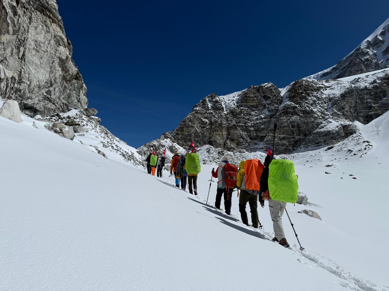
Cho La is the crux. The eastern approach is a steep boulder field, and the top section crosses a small glacier that is snow-covered and genuinely icy in the early morning. You need microspikes or crampons, and you need to know how to walk in them before you get there. After fresh snow it becomes a serious proposition and we will turn a group around rather than cross it badly equipped.
Kongma La is the highest and the longest, with a stiff climb from Chhukhung and a moraine crossing of the Khumbu Glacier at the end when you are already tired.
Renjo La is the most straightforward of the three and has the best view: Everest framed directly across the Gokyo valley, arguably the finest single view in the Khumbu.
Why we run it anticlockwise
We go up the Khumbu valley first, cross Kongma La, then Cho La westward into Gokyo, then Renjo La and out through Thame.
The reason is acclimatisation. Going this way you have eight days and two acclimatisation days behind you before the first pass, so you arrive at 5,535 m properly adapted. Run clockwise, Renjo La comes early and you are crossing 5,360 m with far less time on your legs.
The anticlockwise direction also puts Cho La in the right orientation: the steep icy side becomes an ascent rather than a descent, which is considerably safer.
Who this is for
You should have done a multi-day trek at altitude before this one, ideally something like Everest Base Camp or the Annapurna Circuit. It is not a first Himalayan trek and we will say so if you ask us.
You need to be able to walk eight hours over rough ground on consecutive days, and to be comfortable with the idea that the weather may close a pass and change the plan.
Trips Highlights
- Cross all three Khumbu passes: Kongma La (5,535 m), Cho La (5,420 m) and Renjo La (5,360 m)
- Stand at Everest Base Camp (5,364 m) and climb Kala Patthar (5,545 m) at sunrise
- Reach the Gokyo Lakes (4,790 m) and climb Gokyo Ri for Everest, Lhotse, Makalu and Cho Oyu in one panorama
- See the finest Everest view of the trek from Renjo La, framed directly across the Gokyo valley
- Walk the length of the Ngozumpa Glacier, the longest glacier in Nepal
- Run anticlockwise, so you have eight days of acclimatisation behind you before the first pass
- Trek the quiet Bhote Koshi valley through Thame, the village Tenzing Norgay grew up in
- Link three valleys into one circuit instead of walking the same trail up and back down
- Small groups capped at ten, because a smaller group is safer and faster on a pass day
- Daily oxygen saturation and pulse checks from Day 4 across eleven nights above 4,000 m
Trips Itinerary
You are met at Tribhuvan International Airport and driven to your hotel in Thamel. Nothing is scheduled for the rest of the day.
The briefing this evening is longer than on our other treks. We go through the pass days in detail, check your microspikes and boots, confirm your insurance, and talk honestly about what happens if a pass is closed. If you need to buy or rent spikes, your guide will take you to do it tomorrow morning.
Duration:
Transfer 30 to 45 min
Accomodation:
3-star hotel, Kathmandu
An early start for the flight to Lukla. In peak season this departs from Manthali, four to five hours by road from Kathmandu, so the day begins around 1am. Outside peak season it is a 35-minute flight direct from Kathmandu.
From Lukla the trail drops gently through Chaurikharka and Ghat, following the Dudh Koshi downstream. A short, easy first afternoon that loses height rather than gaining it.
Duration:
3 to 4 hrs trek, 8 km
Accomodation:
Teahouse lodge, Phakding
The trail crosses the Dudh Koshi repeatedly on suspension bridges, climbing gradually through Monjo where you enter Sagarmatha National Park.
After the high Hillary Bridge comes a sustained climb of roughly 600 m in two to three hours up to Namche. On this trek it is a warm-up rather than the hardest day, which is worth remembering when it feels difficult.
Duration:
5 to 6 hrs trek, 12 km
Accomodation:
Teahouse lodge, Namche Bazaar
A rest day, but an active one. We climb to the Syangboche ridge and the Hotel Everest View at 3,880 m, then come back down to sleep at 3,440 m.
Your guide takes the first oxygen saturation and resting pulse readings today. On a twenty-day trek these numbers matter more than on any other route we run, because you will be at altitude for so much longer.
This is also the last place with reliable shops. Anything you are missing, buy it here.
Duration:
4 to 5 hrs hike, 7 km
Accomodation:
Teahouse lodge, Namche Bazaar
A level, open traverse with Everest, Lhotse and Ama Dablam in view for much of the morning, then a steep drop to the river at Phunki Tenga and a climb through rhododendron forest to the monastery.
Tengboche Gompa is the largest in the Khumbu and faces Ama Dablam across the valley. Visitors are welcome at the late-afternoon prayer ceremony.
Duration:
5 to 6 hrs trek, 10 km
Accomodation:
Teahouse lodge, Tengboche
Through Deboche and across the Imja Khola at Pangboche. Above Pangboche the last trees disappear and the landscape becomes open and rocky.
Dingboche at 4,410 m is where thin air stops being an abstraction. From here you will not sleep below 4,000 m again for eleven nights, which is the single biggest difference between this trek and Everest Base Camp.
Duration:
5 to 6 hrs trek, 11 km
Accomodation:
Teahouse lodge, Dingboche
The second acclimatisation day, and on this trek it is not optional in any sense. We climb the ridge towards Nangkartshang, gaining around 650 m, and return to sleep at 4,410 m.
Makalu appears to the east, with Ama Dablam, Lhotse and Island Peak around the valley.
This is the decision point. Kongma La is in two days and it is a 5,535 m pass. If your readings or how you feel today suggest you are not adapting, we change the plan here rather than on the pass, where there are no options.
Duration:
4 to 5 hrs hike, 4 km
Accomodation:
Teahouse lodge, Dingboche
A short day up the Imja valley, deliberately easy because tomorrow is not. Chhukhung is a small settlement under the south face of Lhotse and the Ama Dablam massif, with Island Peak at the head of the valley.
We arrive by early afternoon, which leaves time to rest properly, sort kit and check spikes for tomorrow. Your guide will run through the Kongma La plan in the evening: start time, what to carry, and the turnaround time we will hold to if the weather is wrong.
An optional short walk towards Chhukhung Ri in the afternoon helps acclimatisation if you feel good, but going to bed early is the better choice for most people.
Duration:
4 to 5 hrs trek, 6 km
Accomodation:
Teahouse lodge, Chhukhung
The first pass, and the highest. We start before dawn.
The climb from Chhukhung is steady and long, past a series of frozen lakes into a bowl below the pass, then a final steep pull to the cairn and prayer flags at 5,535 m. From the top the Khumbu Glacier lies below you to the west, with Pumori and Nuptse beyond it.
The descent is the part people underestimate. It drops steeply onto the moraine of the Khumbu Glacier, and then you have to cross the glacier itself, weaving between ice and rubble on an unmarked route, before climbing out the far side to Lobuche. After seven hours this last hour is hard work.
If the weather is poor we do not attempt it. The alternative is to walk down the valley to Dingboche and up the standard trail to Lobuche, which is longer but safe, and it does not cost you the rest of the trek.
Duration:
7 to 8 hrs trek, 10 km
Accomodation:
Teahouse lodge, Lobuche
A hard day following a hard day, which is the toughest sequence on this itinerary. We follow the glacier moraine to Gorak Shep, drop bags and take an early lunch, then continue out across the glacier to Everest Base Camp.
Base Camp sits below the Khumbu Icefall. In April and May it is a working village of expedition tents. You will not see Everest’s summit from here, because Nuptse is in the way.
Back to Gorak Shep for the night at 5,164 m. Almost nobody sleeps well, and after Kongma La yesterday you will feel it. Eat, drink and go to bed early.
Duration:
8 to 9 hrs trek, 11.5 km
Accomodation:
Teahouse lodge, Gorak Shep
Up in the dark for Kala Patthar. The climb is around 380 m and takes most people two hours in the cold with head torches on.
From the top, at 5,545 m, Everest shows its full south-west face with Nuptse, Lhotse, Changtse and Pumori around it. This is the highest point of the trek and the photograph you came for.
Back down for breakfast, then a comparatively gentle afternoon retracing the moraine to Lobuche. Losing 250 m and sleeping lower after two nights at Gorak Shep does more for you than it sounds.
Duration:
7 to 8 hrs, 12 km
Accomodation:
Teahouse lodge, Lobuche
A short, easy day westward, and after the last three days it is very welcome. The trail contours around the head of the valley below Cholatse and Taboche with the Awi Peak ridge opposite.
Dzongla is tiny: a handful of lodges on a shelf below the Cho La, with no shop and no reliable wifi. It is one of the quietest overnight stops in the Khumbu.
Early night. Cho La starts before dawn and it is the crux of the trek.
Duration:
4 to 5 hrs trek, 7 km
Accomodation:
Teahouse lodge, Dzongla
The hardest and most committing day of the trek. We leave around 4am.
The approach climbs gradually to the foot of the pass, then steepens into a boulder field where you use your hands in places. Above that, the final section crosses a small glacier: snow-covered, crevassed in places, and icy in the early morning. This is where microspikes go on, and where your guide will rope the group together if conditions require it.
The cairn at 5,420 m is one of the great moments of Himalayan trekking. Then a long descent on scree and rock to Thangnak, and a further crossing of the Ngozumpa Glacier, the longest in Nepal, before you climb up to Gokyo and its lakes.
If there has been fresh snow, we do not cross. The alternative is to descend to Phortse and walk into the Gokyo valley from below, which adds a day and takes the pass out of the trek. We would rather do that than take a group over Cho La in the wrong conditions.
Duration:
8 to 9 hrs trek, 14 km
Accomodation:
Teahouse lodge, Gokyo
A comparatively short day and the only real rest of the second half. We climb Gokyo Ri, about 570 m above the lake, for what many trekkers rate as the best viewpoint in Nepal: Everest, Lhotse, Makalu and Cho Oyu, four 8,000 m peaks in a single panorama, with the Ngozumpa Glacier and the turquoise Gokyo Lakes below.
It is steep but short, and you are well acclimatised by now.
The afternoon is free. Most people walk out to the fourth and fifth lakes, or sit by the third one and do nothing at all, which after Cho La is a reasonable plan.
Duration:
3 to 4 hrs hike, 4 km
Accomodation:
Teahouse lodge, Gokyo
The third and final pass, and the friendliest of the three. The climb from Gokyo follows the north side of the lake on a good stone-laid trail, steep but well made, to the cairn at 5,360 m.
The view from Renjo La is the one to wait for. Everest sits directly opposite, framed between Nuptse and Lhotse, above the Gokyo Lakes and the glacier. Many people who have walked all three passes say this is the finest single view of the trek.
The descent west is long, on rough ground past Angladumba Tsho and down into the Bhote Koshi valley to Lungden. You have left the crowds entirely by now. This valley sees a small fraction of the Base Camp traffic.
Duration:
7 to 8 hrs trek, 13 km
Accomodation:
Teahouse lodge, Lungden
An easy, gradual descent down the Bhote Koshi valley through Marulung and Taranga. The air thickens noticeably and vegetation returns after two weeks of rock and ice.
Thame is a proper Sherpa village rather than a trekking stop, and it has produced an extraordinary number of climbers, Tenzing Norgay among them. The gompa sits above the village on a cliff shelf and is worth the twenty-minute climb.
Duration:
4 to 5 hrs trek, 10 km
Accomodation:
Teahouse lodge, Thame
A pleasant contouring walk down the valley, rejoining the main trail shortly before Namche.
Namche after seventeen days feels like a city. Bakeries, coffee, hot showers that work, and shops. This is the evening the group tends to remember, because the hard part is genuinely over and everyone knows it.
Duration:
4 to 5 hrs trek, 10 km
Accomodation:
Teahouse lodge, Namche Bazaar
The last walking day. Down the steep section to the Hillary Bridge, then the long undulating trail along the Dudh Koshi through Monjo and Phakding, with a final climb back up to Lukla.
Longer than it looks on the map, but you are extremely fit by now and the air is thick. The evening in Lukla is when the group and the crew eat together and the guides and porters are thanked properly.
Duration:
6 to 7 hrs trek, 19 km
Accomodation:
Teahouse lodge, Lukla
Morning flight back to Kathmandu or Manthali, weather permitting. Flights go early because the wind at Lukla builds through the day.
The rest of the day is yours for a shower, a proper bed and any last shopping. In the evening we hold the celebration dinner and hand out trip completion certificates.
Duration:
35 min flight, or road transfer from Manthali
Accomodation:
3-star hotel, Kathmandu
Transfer to Tribhuvan International Airport about three hours before your flight.
If you have time before departing, we can arrange a Kathmandu valley day around Boudhanath, Pashupatinath and Bhaktapur, or onward travel to Pokhara or Chitwan.
Duration:
Transfer 30 to 45 min
Accomodation:
Departure day
Trips Include
Everything below is covered by the trek price. We are specific about quantities because vague inclusions are where trekking budgets quietly break.
- Airport transfers on arrival and departure in Kathmandu, in a private vehicle
- 2 nights in a 3-star Kathmandu hotel on twin-share, with breakfast (single supplement available)
- 17 nights in teahouse lodges on twin-share, with attached bathrooms where available at Lukla, Phakding and Namche
- All meals on trek: 17 breakfasts, 17 lunches and 17 dinners, plus tea or coffee with every meal
- Fresh seasonal fruit after dinner each evening on the trail
- Celebration dinner in Kathmandu at a Nepali restaurant on your return
- Purified drinking water throughout the trek, so you never need to buy bottled water
- Round-trip flight Kathmandu or Manthali to Lukla, including the road transfer to Manthali when the season requires it
- Licensed, English-speaking trekking guide trained in wilderness first aid and experienced on all three passes
- A second guide on every departure of 5 or more, rather than 7, because pass days need two
- One porter per two trekkers, carrying up to 12 kg each
- All guide and porter wages, meals, accommodation, equipment, insurance and medical cover
- Sagarmatha National Park entry permit (NPR 3,000)
- Khumbu Pasang Lhamu Rural Municipality permit (NPR 3,000). This has replaced the TIMS card in the Everest region
- Comprehensive first aid kit carried by your guide, including a pulse oximeter used at daily altitude checks
- Group safety equipment for the passes, including a rope carried by the guide for the Cho La glacier section
- Everest Women Treks duffel bag, trekking map, sun hat and buff, yours to keep
- Trip completion certificate
- All government taxes, VAT and company administrative costs
Guide and porter wages, insurance, equipment and accommodation are paid by us and already sit inside the price. You are never asked to contribute to staff costs on the trail, which matters more than usual on a trek this long and this high.
Trips Exclude
These costs sit outside the package. Budget roughly USD 400 to 650 beyond the trek price for twenty days, which is more than a Base Camp trek because there are more days and lodge charges rise the further you get from the main trail.
- International flights to and from Kathmandu
- Nepal entry visa: USD 50 for 30 days, which is the one you need for a 20-day trek, obtainable on arrival
- Lunch and dinner in Kathmandu, other than the included celebration dinner
- Travel insurance, which must cover helicopter evacuation and medical treatment above 5,600 m
- Microspikes or crampons, whether you buy or rent them. Rental is roughly USD 20 to 30 for the trek
- Bottled or boiled water, soft drinks, alcohol and hot chocolate on the trail
- Lodge charges for hot showers, device charging, wifi and heating. Budget USD 3 to 10 per item per day, and expect the higher end at Dzongla, Gokyo and Lungden
- Personal trekking clothing and equipment
- Sleeping bag and down jacket if you rent rather than bring your own, about USD 35 each for the trek
- Tips for your guide and porters, customarily 10 to 15% of the trip cost, given as a group at the end
- Extra nights in Kathmandu if a Lukla flight delay extends your stay
- Helicopter transfer if you choose to leave the trek early for any reason other than a medical emergency
- Emergency evacuation costs, which your insurer reimburses
- Anything not listed under what is included
Travel insurance covering helicopter evacuation and medical treatment above 5,600 m is not optional on this trek, and it matters more here than on any other route we run. On the pass sections you are a long way from a road and often a long way from a helicopter landing site. Check the altitude limit in the policy wording rather than assuming, and send us the certificate before you travel.
Packaging Lists
The three things that actually matter
Microspikes or crampons. Not optional on this trek. Cho La has a glacier crossing and Kongma La can hold snow well into the season. Lightweight microspikes are enough in normal conditions and are what most of our trekkers use. They are rentable in Kathmandu or Namche, but bring your own if you can, because fit matters and rental stock varies.
Broken-in boots with real ankle support. Stiffer than you would take to Base Camp, because the pass approaches are boulder fields and you will be on unstable ground for hours. Worn for at least 80 km before you fly.
A sleeping bag rated to minus 20C comfort. Colder than the Base Camp trek needs. You sleep eleven nights above 4,000 m, some of them in lodges at Dzongla and Lungden that are far more basic than Namche. Comfort rating, not extreme rating.
Also genuinely necessary here
Trekking poles, both of them, for the descents off all three passes. Gaiters. Glacier-rated sunglasses in category 4, because the snow glare on Cho La is severe and snow blindness is a real risk. A spare pair of sunglasses, since losing your only pair above 5,000 m ends your trek.
Upper body
3 merino or synthetic base layers, 1 fleece, 1 lightweight down or synthetic mid-layer, 1 waterproof windproof shell, 1 heavy down jacket.
Lower body
2 pairs trekking trousers, 1 pair thermal leggings, waterproof over-trousers, 5 to 6 pairs underwear, 5 pairs trekking socks plus a thick sleeping pair.
Head, hands and feet
Sun hat, warm beanie, buff, category 4 sunglasses plus spares, liner gloves, insulated outer gloves, boots, camp shoes.
For women
Enough menstrual supplies for the whole trek plus a week, since nothing reliable is sold above Namche and twenty days is a long window. Sealable opaque bags for used products, which you carry out. A pee funnel if you plan to use one, practised at home rather than on a cold night at altitude.
Health and documents
Personal first aid kit, blister plasters, rehydration salts, prescription medication in original packaging with a copy of the prescription, sunscreen SPF 50, SPF lip balm, headlamp with spare batteries and a spare headlamp, passport, four passport photographs, insurance certificate, and USD in small denominations.
Bags
One duffel of up to 12 kg carried by your porter (we provide the duffel), plus a 30 to 40 litre daypack. Your daypack is bigger on this trek than on Base Camp, because on pass days you carry more layers, more water and your spikes.
The Lukla flight allowance is 15 kg total including your daypack.
Trips Altitude
Trips FAQs
The questions we get asked about this trek, starting with the ones about difficulty and the passes, because those are what actually decide whether you should book it.
It is the hardest non-technical trek in the Everest region, and we grade it Strenuous. Some operators call it moderately challenging. That is not accurate and it puts people on the route who should not be there.
What makes it hard is accumulation. Eleven consecutive nights above 4,000 m. Six above 4,700 m. Three passes over 5,300 m, each a seven to nine hour day you cannot shorten once committed. Two of the hardest days, Kongma La and the Base Camp day, back to back on Days 9 and 10.
Individual days are not much harder than a Base Camp trek day. Doing twenty of them, most at altitude, is what separates the two.
There is no rope work you need to learn, no climbing and no mountaineering skill required. But it is not purely walking either, and operators who say it is are glossing over Cho La.
You need microspikes or crampons. This is not an optional packing-list item. Cho La crosses a small glacier that is snow-covered and icy in the morning, and Kongma La holds snow well into the season. Lightweight microspikes are enough in normal conditions and are what most of our trekkers use. Practise walking in them at home.
Your guide carries a rope for the Cho La glacier section and will use it to short-rope the group if conditions call for it. That is a precaution, not a sign that you need climbing experience.
The boulder field on the eastern approach to Cho La involves using your hands in places. If scrambling on unstable rock at 5,300 m worries you, this is the section to think about.
Yes, and this is the one trek where we will actually say no.
You should have completed a multi-day trek at altitude before this, ideally something like Everest Base Camp, the Annapurna Circuit or Manaslu. What matters is that you know how your body reacts above 4,500 m, because this route gives you very little room to find out.
We ask about your trekking history before confirming a booking. That is not a formality. Someone who has never been above 4,000 m arriving at Kongma La on Day 9 is a rescue waiting to happen, and it affects the whole group.
If this would be your first Himalayan trek, do Everest Base Camp first and come back for this. Plenty of our trekkers have done exactly that.
We take the valley alternative, and the trek continues.
Every pass on this route has a bypass. If Kongma La is out, we walk down to Dingboche and up the standard trail to Lobuche. If Cho La is out after fresh snow, we descend to Phortse and come into the Gokyo valley from below, which costs a day. If Renjo La is out, we return down the Gokyo valley to Namche.
You lose that pass, not the trek. This is also why we ask for three spare days rather than two.
What we will not do is cross a pass in poor conditions to keep an itinerary intact. Cho La after fresh snow, with a group of trekkers rather than mountaineers, is exactly the situation that produces accidents in this region.
Two reasons, both about safety.
Acclimatisation. Going up the Khumbu valley first means eight days of walking and two acclimatisation days before you reach the first pass. You arrive at Kongma La at 5,535 m properly adapted. Run the other way, Renjo La comes on about Day 7 and you cross 5,360 m with far less time on your legs.
The direction of Cho La. The eastern side is the steep icy one. Anticlockwise you climb it, which is much safer than descending it, particularly on a glacier in the morning.
The trade-off is that you finish through Thame and the Bhote Koshi, which is quieter and less dramatic than starting there. We think that is the right way round.
You need to walk eight hours over rough ground and then do it again the next day. That is the standard, and it is more demanding than the Base Camp trek.
Twelve weeks of preparation, minimum. Three hill or stair sessions a week, plus back-to-back long walks at weekends carrying a loaded pack. The single most useful training you can do is an eight-hour walk on Saturday followed by another on Sunday, because that replicates Days 9 and 10.
Strong legs are not enough on their own. What actually gets people over three passes is being able to keep going on the second and third hard day in a row.
Acute Mountain Sickness is your body reacting to reduced oxygen. Mild symptoms like headache, nausea, poor sleep and breathlessness affect most trekkers at some point.
This route carries more altitude exposure than any other trek we run. Eleven nights above 4,000 m means your body has less opportunity to recover between hard days.
Our controls: two active acclimatisation days before the first pass, sleeping altitude limited to about 500 m of gain per day on the approach, daily oxygen saturation and pulse checks from Day 4, and a second guide on every departure of five or more so someone can descend with a trekker without ending the trek for everyone.
If symptoms worsen the treatment is descent, and on this route the descent is often longer and more complicated than on the Base Camp trail. That is precisely why we act early rather than waiting.
On a twenty-day trek this is more likely than on a short one, and the plan depends on where you are.
Before Lobuche, descent to Pheriche or Namche is straightforward on foot with a guide. From Gorak Shep or Dzongla, the options are walking out or a helicopter evacuation if there is a medical reason, which your insurer covers. From Gokyo, the valley walk out to Namche is two days.
Because every departure of five or more carries a second guide, one can go down with you while the group continues. There is no extra charge for a guide accompanying you, though a non-medical helicopter is at your own cost.
More basic once you leave the main trail, and you should expect that.
Lukla, Phakding and Namche are comfortable, usually with attached bathrooms and reliable hot showers. Tengboche and Dingboche are fine.
Chhukhung, Dzongla and Lungden are small settlements with a handful of lodges each, shared toilets, no reliable wifi and no shops. Gokyo is better, and it has become a proper trekking hub. Rooms in these places are cold and unheated, and the dining room stove is the only warm space.
None of this is a hardship if you expect it. It becomes one if you have been reading about the Base Camp trail and assume it will be the same.
Narrower than the Base Camp trek, because the passes decide it.
Late September to mid November is the best window. The monsoon has cleared the air, snow on the passes is at a minimum, and the views from Gokyo Ri and Renjo La are at their sharpest. Mid October is ideal.
Late March to May is the other good window. Slightly more residual snow on Cho La early in the season, but warmer and with rhododendron in flower lower down.
December to February we do not run this trek. The passes hold deep snow, several high lodges close, and Cho La in winter is a mountaineering objective rather than a trekking one.
June to August is monsoon. Cloud, no views, and the passes are dangerous.
Two permits, both included in your price: the Sagarmatha National Park entry permit (NPR 3,000) and the Khumbu Pasang Lhamu Rural Municipality permit (NPR 3,000).
A TIMS card is not required for the Everest region. The Khumbu Pasang Lhamu permit replaced it, and the municipality fee rose from NPR 2,000 to NPR 3,000 in September 2024. Many operator websites still list a TIMS card for this trek. That information is out of date.
Note the visa too: a 20-day trek plus arrival and departure days means you want the 30-day visa at USD 50, not the 15-day one.
Budget USD 400 to 650 beyond the trek price for twenty days. That is more per day than a Base Camp trek, because lodge charges rise the further you are from the main trail.
Expect hot showers at USD 4 to 10, device charging USD 3 to 8, and wifi USD 5 to 10 a day at Dzongla, Gokyo and Lungden.
Bring Nepali rupees in small notes from Kathmandu, and bring more than you think. The ATM in Namche is unreliable and there is nothing beyond it. Twenty days is a long time to be short of cash.
Tipping is customary at 10 to 15% of the trip cost, pooled by the group and given on the last evening in Lukla.
A policy that explicitly covers trekking to 5,600 m and helicopter evacuation and medical repatriation. Most standard travel insurance caps altitude cover well below that, and many exclude helicopter rescue entirely.
This matters more here than on any other trek we run. On the pass sections you can be a long way from a helicopter landing site, and an evacuation may involve being walked down for several hours first.
Check the altitude limit in the policy wording rather than assuming, and send us the certificate before you travel. We will ask to see it before you fly to Lukla.
Yes. Solo travellers make up a large share of every departure we run, and you are with a licensed guide throughout.
Twin-share rooms are allocated with someone of the same sex unless you request and pay for a single, though single rooms are not always available at Dzongla, Chhukhung and Lungden, where there are only a few lodges.
The Bhote Koshi and Gokyo valleys are quieter than the Base Camp trail, which most people find is the appeal rather than a concern. You are never walking a section alone unless you want to.
Note this trek needs a minimum of two people, so a solo booking joins an existing departure or is quoted as a private trip.
Good to Know
The questions we get asked about this trek, starting with the ones about difficulty and the passes, because those are what actually decide whether you should book it.
Kongma La, 5,535 m, Day 9. The highest of the three and the longest day of climbing. A steady ascent from Chhukhung past frozen lakes, then a steep final pull. The descent drops onto the Khumbu Glacier moraine and you cross the glacier itself on an unmarked route before climbing out to Lobuche. That last hour, after seven hours of walking, is what people remember.
Cho La, 5,420 m, Day 13. The crux. A boulder field where you use your hands, then a small glacier at the top that is snow-covered and icy in the morning. Microspikes required, rope carried by the guide. The descent to Thangnak is long scree and rock, followed by a crossing of the Ngozumpa Glacier before Gokyo. Eight to nine hours, and the day that most often gets changed by weather.
Renjo La, 5,360 m, Day 15. The most straightforward and the most beautiful. A well-made stone staircase up from Gokyo, and a view from the top of Everest framed between Nuptse and Lhotse above the lakes. The western descent is long and rough but not difficult.
All three are day-long commitments with no shelter between the last lodge and the next. Start times are between 4am and 6am depending on the pass and the forecast.
The distinguishing feature of this trek is not its highest point. Kala Patthar at 5,545 m is the same as the Base Camp trek. It is the time spent high.
You sleep eleven consecutive nights above 4,000 m and six above 4,700 m. Recovery between hard days is worse than at lower altitude, appetite drops and stays down, and small injuries heal slowly. Most people lose weight on this trek.
What we build in: two active acclimatisation days before the first pass, sleeping gain limited to about 500 m per day on the approach, a deliberate easy day at Chhukhung before Kongma La, a descent to Lobuche after two nights at Gorak Shep, and a short day to Dzongla before Cho La.
What we ask from you: drink 3 to 4 litres a day for twenty days, eat when you do not want to, no alcohol above Namche, and tell your guide early. Daily oxygen saturation and pulse readings are recorded from Day 4, and on this route the trend across two weeks tells us more than any single number.
From Chhukhung on Day 8 until Namche on Day 17 you are mostly off the Everest Base Camp trail. That is the appeal, and it has consequences worth understanding.
Lodges are fewer and smaller. At Dzongla and Lungden there are a handful, with no shop and no reliable wifi. If a lodge is full in peak season, the next one may be hours away.
Help is further off. A trekker who needs to descend from Dzongla or Gokyo has a longer and more complicated journey than one on the main trail. Helicopter landing sites exist but are not everywhere, and cloud closes them.
This is why every departure of five or more carries a second guide, why we cap groups at ten, and why we act on early symptoms rather than waiting to see. On the Base Camp trail you can afford to watch a mild headache for a day. Here we would rather not.
Twenty days, and washing gets basic quickly. Hot showers work reliably at Lukla, Phakding, Namche and Gokyo, usually USD 4 to 10. Elsewhere above Dingboche they are unreliable, cold, or not worth the chill afterwards. Most people manage on unscented wet wipes and a quick-dry towel between Namche on the way up and Namche on the way back.
Bring your own toilet paper and hand sanitiser, and more than you would take on a shorter trek. Lodge toilets at Chhukhung, Dzongla and Lungden are shared, usually a squat toilet or a basic outhouse. A headlamp for night trips matters when it is well below freezing.
Rooms are twin-share, walls are thin and most doors have no lock. Bring a sarong or light towel to change under.
Drink fully even though it means getting up at night. Urinary tract infections are common on trek because people cut back on water to avoid the cold walk to the toilet, and on a twenty-day route that is a real risk rather than a theoretical one.
Women should bring enough menstrual supplies for the whole trek plus a week, since nothing reliable is sold above Namche and twenty days is a long window. Altitude and sustained exertion often shift cycle timing. There is no waste disposal on the trail, so used products are carried out in sealable opaque bags. Worth telling your guide, because cramps and fatigue overlap with early altitude sickness.
Every departure runs with a licensed, English-speaking guide trained in wilderness first aid who has crossed all three passes. On this route that experience is not a nice extra: route-finding on the Khumbu Glacier moraine and on Cho La is genuinely difficult in poor visibility.
We put a second guide on every departure of five or more, rather than seven as we do on our other treks, because a pass day needs one person at the front and one at the back.
Groups are capped at ten rather than fourteen. A smaller group crosses a pass faster, stays together more easily, and is quicker to turn around if the weather changes.
Porters carry up to 24 kg shared between two trekkers. All our staff are insured, equipped with proper boots, jackets and eyewear, paid above the government minimum, and accommodated and fed at our cost. On the pass days our porters carry the same conditions you do, and they are equipped for it.
Carry Nepali rupees in small denominations, and bring more than you would for a Base Camp trek. The ATM in Namche is unreliable and there is nothing beyond it in any direction. Twenty days is a long time to run short.
Expect to pay for what is free in Kathmandu, at higher rates than the main trail: hot showers USD 4 to 10, device charging USD 3 to 8 per device, wifi USD 5 to 10 per day. A power bank of 20,000 mAh or more pays for itself several times over here, and cold drains batteries fast, so sleep with your phone and power bank inside your sleeping bag.
Mobile coverage is patchy on the main trail and largely absent in the Gokyo and Bhote Koshi valleys. Everest Link cards work at Gokyo and Namche. Tell people at home you may be out of contact for several days at a time, because on this route you genuinely will be.
We include purified water throughout precisely so nobody buys bottled water. Plastic bottles are a serious waste problem in the Khumbu, where nothing is recycled and much is burned.
This matters more on the pass sections. Waste that is a nuisance on the main trail is a lasting problem at Dzongla and Lungden, where there is no collection at all. Carry out everything, including sanitary waste, wrappers and used batteries.
Ask before photographing people, particularly monks and elderly villagers. Walk clockwise around mani stones, chortens and prayer wheels, keeping them on your right.
Yaks have right of way. Always step to the inside of the trail, against the hillside, never the drop side.
Where there is a choice we use Sherpa-owned lodges and buy locally. In the quieter valleys, where a lodge may see a handful of groups a week, that choice makes a much bigger difference than it does in Namche.
This trek needs a minimum of two people, and we cap departures at ten.
We will ask about your trekking history before confirming. If we do not think the route is right for you yet, we will say so and suggest Everest Base Camp first. That conversation costs us bookings and we would rather have it than deal with the alternative at 5,535 m.
A 20% deposit confirms your place, with the balance due in Kathmandu before you fly to Lukla.
Cancel more than 30 days out and the deposit is refundable less bank charges. Inside 30 days the deposit is retained but transferable to another departure within 12 months.
Weather delays and closed passes are not cancellations. If a pass is out we take the valley alternative and the trek continues at the same standard.
This trek needs a minimum of two people, and we cap groups at ten rather than fourteen. On pass days a smaller group moves faster and is far easier to keep together in bad weather.
Book four to five months ahead for October and April. Twenty days of lodge space is harder to hold than twelve, particularly at Dzongla, Gokyo and Lungden, where there are only a handful of lodges.
A 20% deposit holds your place, with the balance due in Kathmandu before you fly to Lukla.
We will ask about your trekking history before confirming. This is not us being difficult. Putting someone on this route who has never been above 4,000 m does them no favours and puts the rest of the group at risk of a rescue day.
Keep three spare days before your international flight, not two. This trek has more ways to run long than most: a Lukla delay at either end, a pass closed by snow, or a day lost to someone in the group needing to descend. Three days of margin is the sensible number.
Which airport you fly from depends on the season. In March, April, May, September, October and November, Lukla flights usually operate from Manthali, four to five hours by road from Kathmandu with a very early start. In the quieter months they generally run direct from Kathmandu. We confirm which applies to your dates when you book, and the road transfer is included either way.
Twelve weeks of training, minimum. Three hill or stair sessions a week, plus back-to-back long walks at weekends carrying a loaded pack. The single best preparation for this trek is walking eight hours on a Saturday and then doing it again on the Sunday.